Water is the foundation of life on Earth and that is particularly apparent in Oregon’s high desert. We have conserved more than 20,000 acres of land and prioritized restoration of aquatic areas that could use a boost. One example is a small section of stream that can have big benefits for fish and wildlife.
In 2022, we began on-the-ground work at Trout Creek Ranch. Since then, we’ve been busy developing and implementing management plans across nearly 17,000 acres of private land and 500,000 acres of public land grazing allotments. Trout Creek Ranch spans the Pueblo and Trout Creek Mountains. This dramatic conservation area covers nearly 800 square miles and provides climate-resilient habitat connectivity within more than one million acres of intact high desert landscapes that stretch from the Sheldon National Wildlife Refuge to Steens Mountain Wilderness. It includes grasslands, aspen woodlands, creeks, wet meadows, and sagebrush-steppe. Water is critical to the desert landscape and we’re focused on protecting and restoring key springs, wetlands, and streams across the project area.
In 2022, 16 creeks and 125 springs were surveyed to determine restoration priority areas across this vast mountainous terrain. Cottonwood Creek made the top of the list for restoration in the Trout Creek Mountains. Nestled in a canyon, its year-round flows sustain a variety of high desert species, some of special concern. The waters are potential spawning grounds for trout and these lands host one of the most significant population strongholds in the U.S. for greater sage-grouse. From Columbia spotted frog to pronghorn antelope, many animals rely on the creek flows.
Cottonwood Creek has eroded banks and incisions (or deep channel cuts) in places, but the 2.2-mile project area has a mature riparian plant community, active beavers and perennial flow downstream to aid restoration efforts. Multiple partnerships are helping improve plant and wildlife habitats and grazing management so it can sustain itself. For early interventions of the creek we’re working with The Nature Conservancy (TNC), Bureau of Land Management (BLM), Oregon Department of Fish and Wildlife (ODFW), Oregon State University Extension Services, Agricultural Research Service of the U.S. Department of Agriculture (USDA ARS), the U.S. Fish and Wildlife Service Partners for Fish and Wildlife Program, and Anabranch Solutions.
Hosford cites a lack of vegetation upstream as one of the creek’s problems since plants stabilize the banks by holding things in place, and affect the speed and direction of water. Without a variety of plants and woody debris, water can flow fast and dig deep, becoming a straightened, incised stream. Incised stream channels result in lowered water tables, cutting off water’s access to historic floodplains during high flow events.
“Streams do want to be a certain way, and sometimes they’ve been so degraded, they’re unable to reach those pathways properly, especially if they don’t have the help of the beaver or the vegetation,” Hosford explained. “Sometimes they just need a little bit of a nudge to get going back to their natural functions and this is where tools like process-based restoration can really help.”
Similar projects can take three to five years to install restoration structures on site, but this first phase happened within one year thanks to ODLT’s partners. To help with wildlife crossings and the planned work, ODLT volunteers got their feet wet last summer removing old and obsolete fencing. In fall, staff from ODLT, TNC, Anabranch Solutions and more volunteers spent two weeks working to restore the creek. This included 15 wood jams that guide water during high flows and 27 beaver dam analogs (BDAs) that mimic the real structures to slow down water and help the stream pool and capture sediment. No heavy equipment is needed, making the work low-tech, and it is process-based since it relies on the creek and the natural engineering of beavers to take over afterward. The simplicity of these approaches is a highlight for Hosford, along with some instant gratification.
“It’s so fun and has immediate results. As soon as you build the structure, the system starts changing right away. Even in the week we were out there, you could see big changes in the stream. The way the water was slowing down, pooling, and spreading out, which is great and what we wanted to see,” Hosford recalled.
Small crews also planted nearly 800 willow cuttings and built a fencing exclosure to prevent browsing by deer or beaver to give the vegetation a head start. Plant surveys are another part of the project, and those native plantings are expected to draw in more wetland birds, which are being monitored, too. The project area is within the Oregon Canyon and Trout Creek Mountain Woodlands Important Bird Area (IBA). The IBA program is a global initiative of Birdlife International, implemented by the National Audubon Society and other partners, to conserve areas vital to birds and other biodiversity. Restoration is expected to benefit important bird species relying on healthy riparian areas, including state sensitive yellow breasted chats and willow flycatchers. Since the area is difficult to access and birds aren’t always around when people come to count them, TNC installed seven acoustic recorders (autonomous recording units or ARUs) to detect any bird activity near dawn and sunrise from May through September.
Wetland shrubs fade out as you move up Cottonwood Creek and TNC Rangeland Scientist Cameron Duquette notes that prior data shows related differences in bird communities. This is a good indicator that vegetation structure and healthy riparian corridors do have an effect on bird communities in this landscape. “As you get up higher in the creek and don’t have your willows and dogwoods, a lot of blackbirds are up there, whereas the wrens and sparrows and warblers were really limited to the areas that are impacted to a lesser degree currently,” Duquette observed.
Duquette is really excited about the new ARU technology and how it can detect bird activity that would usually be missed unless people are listening in the field 24/7. He stressed that just because a species uses an area for a week or two during summer, it doesn’t mean it’s not important for those species. Figuring out that significance and the unknowns adds to the excitement. “Especially for these little pockets in the middle of the desert,” he declared.
Using aerial photos from drones or satellite imagery provide ways for researchers to collect data without having to traverse the whole project site. The extent and height of woody plants can be interpreted through imagery and help explain changes in vegetation, bird communities and the outcome of the work as a whole. It may take three to five years to see the full impacts of this work on Cottonwood Creek , but everyone feels it’s worth the wait.
Feature image: A sunset in the Trout Creek Mountains is reflected within a beaver pond in the downstream section of the 2.2 mile Cottonwood Creek Project. — Owen Baugman
Published January, 2025
Learn More
- Check out resources of natural beaver recovery on eastern Oregon landscapes from Western Beavers Cooperative, along with the Beaver Conservation Strategy of the U.S. Fish & Wildlife Service.
- Find and protect an Important Bird Area (IBA) near you through the National Audubon Society and learn through Birdlife International how these IBAs are also Key Biodiversity Areas (KBAs).
- Discover some low-tech process-based restoration resources from Utah State University Restoration Consortium.
- Dive into the 2022 research that helped prioritize conservation plans at Trout Creek Ranch.
- Demonstrating restoration plans was part of a tribal gathering at Trout Creek Ranch last fall.
STAY TUNED!
- We’ll share updates on Cottonwood Creek restoration as we go!
Discover details of the highlighted regions
View Wildlife Camera Videos
More perspectives
Related Reads
A land of learning
Local Tribal members shared stewardship practices to inspire youth.
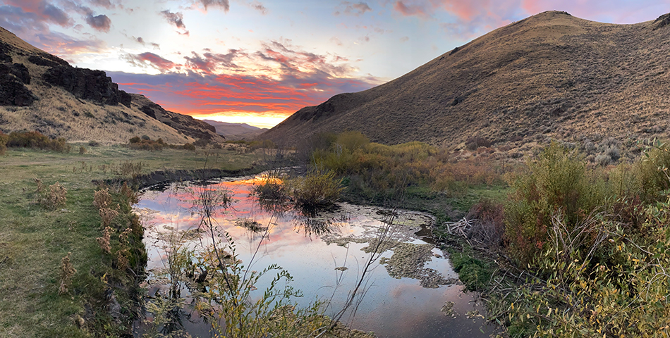
Looking out for the birds
Volunteers help guide restoration plans with wetland bird surveys.
Watching wildlife
Wildlife cameras help with conservation plans for animals throughout the year.
Virtual fences mooove cows online
Virtual fence is a new technology that can help land managers maintain wildlife connectivity in permitted grazing areas.
Tribal Gatherings
Tribal leaders discussed the Native history and stewardship of their homelands at Trout Creek Ranch.
Research fueled by fire
Oregon State University finished 10 years of fieldwork on sage-grouse responses to wildfire.
Tribal Stewards
Tribal teens lead on conservation efforts through Northwest Youth Corps.
Spring returns
Rod Klus returns to researching sage-grouse for Oregon Department of Fish and Wildlife.
Mountains of Research
Researchers spent a summer in the mountains and left with more than data.
Spreading wings in conservation
Jack Strang created new connections to the high desert during our first internship.
Neighbors helping neighbors fight fires
Rangeland Fire Protection Associations protect the high desert and each other.
Watching for wildfires
A live camera on Beatys Butte helps wildfire efforts in the high desert.
Spring into recreation & conservation
John Sterling works at the intersection of both as a volunteer board member.
Balancing a range of concerns
Angela Sitz brings wild and working lands together.
Wildlife encounters
Land Trust volunteers are keeping track of animals on the ground and on camera.
Keeping it connected
Closing the unnatural gap between wildlife refuges opens doors for pronghorn.
Seeing the land in a different Light
Northern Paiute Tribal member Wilson Wewa brings a Native perspective to ODLT's work.